
Etowah Indian Mounds Historic Site: Know Before You Go
The Etowah Indian Mounds are a fantastic north Georgia archaeological site for both adults and children. Head out to Cartersville to explore this 1000-year-old Mississippian site!
The Etowah Indian Mounds State Historic Site is the best-preserved Mississippian settlement in the southeast. Its three surviving earthen mounds include Mound A, which is the second-largest mound in the entire United States.
As if that weren’t enough, the on-site museum contains fascinating artifacts and informative displays on Mississippian life. If you are in northern Georgia or southern Tennessee, don’t miss this rare opportunity to learn about the Ancient South.
Read on for my glowing review of the Etowah Indian Mounds. I’ll tell you all about what the site is like, give you some tips, and explain why you should definitely visit.

This post may contain affiliate links and I may receive a commission, at no extra cost to you, if you make a purchase through a link. Please see my disclosures.
Etowah Indian Mounds: Quick Facts
- Where: 813 Indian Mound Rd SE, Cartersville, GA 30120
- Ticket Cost: $6 per adult, $4 per youth (ages 6-17), $2 per child
- Time Needed: 1-2 hours
The Etowah Indian Mounds State Historic Site is located a few miles off I-75 in Bartow County, Georgia. It is a 50-minute drive from Atlanta and a 70-minute drive from Chattanooga. This makes it a perfect destination for a day trip.
Free parking is available at the site, as are public restrooms. Dogs are allowed at the mounds, but they are not allowed inside the archaeological museum.
The main attractions are the three surviving earthen mounds, which are located along an interpretive trail. But you should also visit the on-site archaeological museum and head down to the river to see the fish weir.
What are the Etowah Indian Mounds?
The three large mounds are the most visible remains of the chiefdom of Etowah, a Mississippian settlement occupied from 1000 to 1550 C.E. Chiefs at Etowah reached the height of their power between 1250 and 1375.
Etowah was part of the broader Mississippian culture, a civilization which dominated the southeastern and midwestern United States between 800 and 1600 C.E. This culture originated in the Mississippi River Valley (hence its name) and soon spread all over.
The Mississippian culture featured chiefdoms or geographical units ruled by a single chief. Each chiefdom had one or more mound centers or major settlements.
From Texas to Illinois to North Carolina, distinctive platform mounds remain. The Etowah Indian Mounds are the best-preserved Mississippian site in the southeast, so we are lucky to have them here in Georgia.
For much of its history, Etowah was an extremely influential chiefdom. Thanks to the nearby Etowah River, there were fertile fields to farm. Furthermore, Etowah was near the boundary between two geographical regions – the Ridge and Valley Province and the Piedmont.
This meant that rulers at Etowah could take advantage of resources (plants, animals, and minerals) from both regions. They could also engage in trade with people living all over Georgia. At the height of its power, Etowah had influence over chiefdoms as far south as Florida.
Etowah was occupied in three phases between 1000 and 1550 C.E. Archaeologists believe that the settlement was burned in 1375 and this caused its major decline. When the Spaniards led by Hernando de Soto visited the area in the 1540s, Etowah was under the power of the nearby chiefdom of Coosa.

Exploring the Etowah Indian Mounds State Historic Site
When you visit Etowah, it is easy to envision how things might have looked almost a thousand years ago. A defensive ditch encircles the 54-acre site on three sides, while the Etowah River provides the southern boundary.
You can wander all over the site and even climb the mounds themselves. Interpretive signage will help you to know exactly what you are looking at.
But before you head out to the mounds, I recommend that you start in the archaeological museum (which is where you purchase tickets, anyway). The exhibits will prepare you to appreciate the site fully.
Etowah Archaeological Museum
My favorite part of the archaeological museum was a reconstructed model of the ancient mound center. You can see the three major mounds arranged next to the plaza, as well as numerous smaller huts in the vicinity. A wooden palisade surrounds the site on three sides.

The museum also displays artefacts such as jewelry, weapons, and dishes from the Mississippian people. Informative panels explain how the inhabitants of Etowah lived and flourished in the area.
The archaeological museum is famed for its two large stone effigy statues, one man and one woman. Archaeologists found them buried in Mound C. In his book on Etowah, Adam King suggests that inhabitants buried the effigies to protect them during an attack.

The statues probably represent the original chief and his oldest sister, who was the mother of his heir. Mississippian society was matrilineal, so the chief was succeeded by his sister‘s son, not his own son.
In addition to the exhibits, a 15-minute documentary film provides an excellent overview of Etowah’s history.
Pro Tip: The documentary is also available online on the GA State Parks website. So if you don’t have much time to spend on site, you can watch the film in advance!
In my opinion, the museum was just the right size. Not too big, but with enough displays to acquaint you with the Mississippian culture. We spent about 30 minutes there, but you could go through even faster if you want.
Interpretive Trail
The 3/8-mile Interpretive Trail starts outside the archaeological museum and leads to Mounds A, B, and C. On the way you pass a reconstructed Mississippian house and the defensive ditch that once protected Etowah.
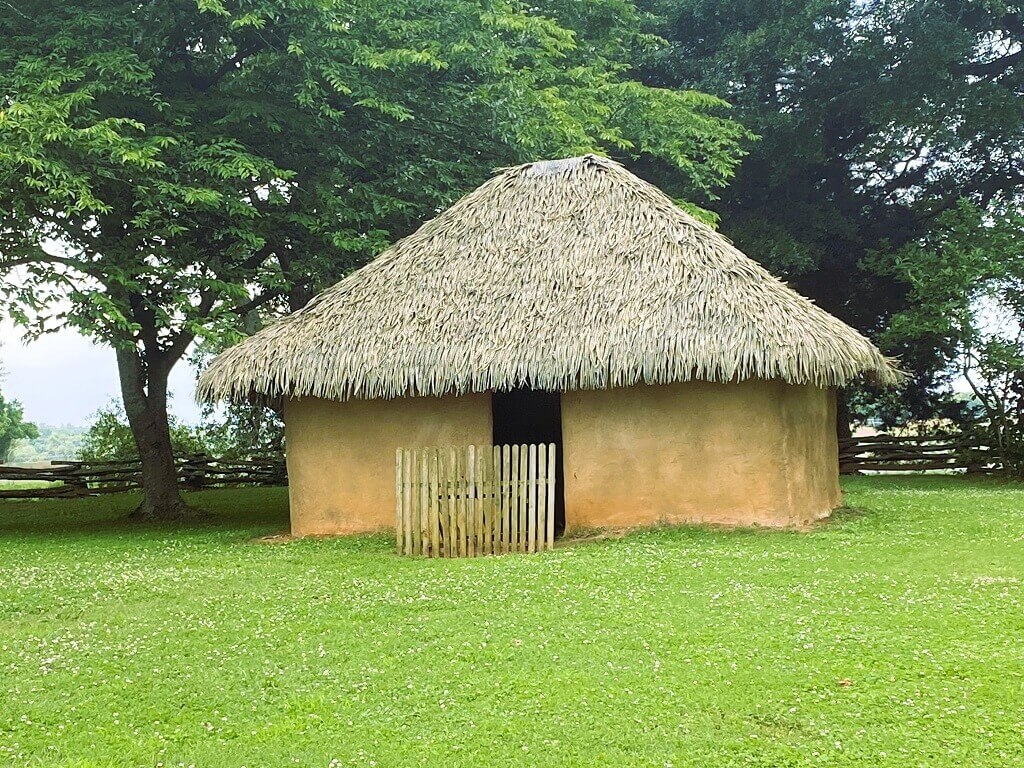
The Mississippian house is located just outside the archaeological museum. The historical site constructed it in the wattle and daub style used by the Mississippian culture. Basically this means that they wove strips of river cane between wooden posts and then plastered them over with mud.
Long ago such structures would have dotted the landscape of Etowah. Go inside the house and imagine what it might have been like to live there!

Next the Interpretive Trail will lead you to a bridge built over a large defensive ditch. This ditch is around 800 years old and served as protection from enemy chiefdoms.
Originally there was a 12-foot high wooden palisade on the inside of the trench in order to provide even greater safety.


Once you cross the bridge, you are within the bounds of the mound center. It is time to view Etowah’s main attraction: the mounds.
Mounds A, B, and C
There are three primary mounds at Etowah, known as Mounds A, B, and C. The mounds are arranged around a large plaza where most of the activities of the settlement took place. Today the plaza has disappeared under grass and weeds, but a sign marks its location.
You will arrive at Mound A first. As I mentioned above, Mound A is the second-largest mound in the United States. It rises up 67 feet into the air, which makes it is as tall as a 6-story building.

Archaeologists believe that the chiefs of Etowah lived on top of Mound A. They accessed the mound via a massive staircase (over 20 feet wide) built of clay and logs.
Today there are modern stairs constructed over where the ancient ones would have been. You can climb up to the top and imagine what it must have been like when the chieftains lived there. Plus there is a beautiful view of the surrounding countryside (and of the other mounds).
Next you can walk to the nearby Mound B, which is 35 feet tall. Archaeologists believe that the Native Americans carried out elite rituals on and around this mound. The mound was encircled by a wooden stockade to ensure that only the elite had access.

Finally, head to Mound C, which at 25 feet high is the smallest mound at Etowah. Mound C is also the only mound at Etowah that has been completely excavated (and then reconstructed). These excavations revealed a lot about the mound and Etowah as a whole.
Mound C served as a place for elite burials during the height of Etowah’s power. Archaeologists have discovered over 350 burials here. Many of the deceased were accompanied by fancy grave goods such as copper decorative plates and carved bone jewelry.
Mounds B and C are significantly lower than Mound A, but it is still fun to climb up on top of them. The inhabitants of Etowah built all three mounds in stages over dozens or even hundreds of years.

The River Walk & the Weir
After you visit Mound C, head into the trees toward the Etowah River. The river formed the southeastern boundary of the town, while the defensive ditch encircled the other three sides.
The Etowah River was a major benefit to the Native Americans, since it made the nearby fields fertile for agriculture and offered a supply of fish. Rivers were also important for travel and trade.
If you turn left and head along the river, you can see the remains of a fish trap dam (or weir). Rocks form a V shape in the center of the river. There is an opening at the tip of the V, where the fishermen place traps. The fish would swim into the V and then fall into the trap.
Sometimes the river is high and the rocks of the dam are almost invisible. On the day we were there, we could spot where the fish dam must be based on the water patterns.

After you visit the fish trap dam, head to the right along the river to follow the 5/8-mile River Walk nature trail. Signs will tell you about plants that Etowah’s inhabitants used in their everyday lives.
The trail will eventually take you back to the museum and the parking lot. You will pass by a large borrow pit. This giant pit supplied a lot of the earth for the mounds.
Pro Tip: There are many lovely benches near the river bank where you can sit and admire the water. My family and I relaxed there for almost 30 minutes. It would be a great place to have a picnic lunch!

Visiting the Etowah Indian Mounds With Kids
The Etowah Indian Mounds are an excellent site to visit with kids. Children will love popping into the hut and climbing the stairs to the top of the mounds. And, as I mentioned up above, there are many benches perfect for a picnic by the river – as well as picnic tables next to the parking lot.
If your children are old enough to read, then stop to pick up some activity sheets in the entrance to the archaeological museum. They have
- a word search (with items such as arrow, atlatl, fish weir, etc.)
- an Etowah Indian Mounds Scavenger Hunt sheet (where you fill in the blanks with information from signs and displays)
- an Etowah Visitor Activity Sheet (with spots to sketch different items found in the museum)
Just remember to bring some clipboards for your kids to press on!
Learn More about the Mississippian Culture
If you would like to learn more about the Mississippian culture and specific mound sites, then I highly recommend Eric E. Bowne’s Mound Sites of the Ancient South.
The first few chapters discuss the Mississippian customs and society more broadly. I learned all kinds of fascinating things. For instance, the culture was matrilocal and matrilineal. This means that men moved in with their wives’ families after marriage and that kinship and inheritance was determined through the female line.
Children were raised by their maternal uncles, not by their fathers. Fathers – who were busy raising their sisters’ children – treated their own children like we would treat nieces and nephews.
Intriguing, right? The remaining chapters of Mound Sites of the Ancient South focus on specific archaeological sites and their interpretations. There are a few useful pages dedicated to Etowah!
Frequently Asked Questions about Etowah
How much does it cost to go to the Etowah Indian Mounds?
The standard entry fees are as follows:
- Adults (18–61): $6.00
- Seniors (62+): $5.00
- Youth (6–17): $4.00
- Children (under 6): $2.00
If you have a Georgia public library card, you may have access to the Library Loan Program. This program allows you to check out a historic site pass, which then gives you free entry for up to 2 visitors.
Or, if you are a frequent visitor of Georgia State Parks, you can save by purchasing a historic site pass. We buy a family site pass every year, and it saves us so much money.
What does the word Etowah mean?
“Etowah” is derived from the Muscogee (Creek) word italwa, which means “town.” The Muscogee, along with other southeastern tribes, are descended from the Mississippian peoples.
Other modern city names derived from italwa are Tallahassee and Tulsa.
Who built the Etowah Indian Mounds?
The Etowah Indian Mounds were built by the Mississippian culture. Mississippian chiefdoms once stretched all over the American south and midwest, but their way of life could not survive European arrival.
Hernando de Soto’s expedition in the 1540s left infectious diseases in its wake and Mississippian political structures ultimately collapsed. The modern-day descendants of the Mississippian culture are the Muscogee (Creek).
What were the Etowah Indian Mounds used for?
In the Mississippian culture, the chief and his family usually lived on top of the main mound. Other mounds served as homes for the elite and sites for ritual activities. Some mounds were in fact burial mounds.
At Etowah, archaeologists believe that Mound A was where the chief lived. Mound B served as a spot for elite rituals, and Mound C was a burial site for the elite.
When did the Mississippian civilization live at the Etowah Indian Mounds?
Etowah was inhabited between 1000 and 1550 C.E (with two brief phases of abandonment). From 1000 to 1200, Etowah was a small settlement. Construction probably began on Mounds A and B, but they were nowhere near their current size.
The Etowah River valley was abandoned from 1200 to 1250, but around 1250 the Mississippians returned. The glory days of Etowah had arrived.
Between 1250 and 1375, Mounds A and B reached their full height and Mound C was constructed. This is also when the ditch, the palisade, and the plaza were added to the site. Etowah’s influence expanded all over Georgia.
Fire destroyed the palisade around 1375, probably due to an enemy attack, and inhabitants fled. Although the Mississippian people returned about a hundred years later, Etowah never regained its former power. A final abandonment occurred around the 1550s.
If you want to read the nitty-gritty details and dive into the archaeological evidence, then the best resource is Adam King’s Etowah: The Political History of a Chiefdom Capital.
Final Thoughts
Did you know about this ancient settlement hidden in the hills of rural Georgia? The Etowah Indian Mounds State Historic Site is a must-visit destination for anyone who cares about Native cultures or American history in general.
I left feeling like I had experienced a true glimpse into the Mississippian past, and I hope you will go explore this amazing Native American site, too. If you are looking for other ancient sites in Georgia, check out my post on Rock Eagle Effigy Mound in Eatonton.
PRO TIP: There are plenty of nice restaurants in nearby Cartersville if you would like to get a meal after exploring Etowah. We drove to the West End Commons and ate at Cafe Sundae, a charming family-owned establishment. Their smoothies were amazing, as were their bacon guacamole croissant and their turkey burger!
YOU MAY ALSO LOVE:
Visit New Echota, the Former Cherokee Capital
Epic Things To Do in Cherokee, North Carolina

Thank you for this detailed comprehensive write up on the Etowah Indian Mounds. I’ve lived within an hour of here for most of life and have not made the time to see it, but now I’m inspired!
I hope you make it out to the mounds, Lara! They are definitely worth a visit! 🙂